Bridal Veil Falls

City / town · Oregon

Bridal Veil and Corbett

Bridal Veil Falls

On this page

Overview

Bridal Veil and Corbett are communities in Multnomah County, Oregon, at the west end of the Columbia River Gorge, about 25 miles east of Portland.

8 sights · 1 things to do · 2 places to stay

Updated from Wikivoyage on 1 October 2026 · Something wrong or missing? Improve it on Wikivoyage

Best things about Bridal Veil and Corbett

Bridal Veil Falls

Bridal Veil Falls

Horse Tail Falls

Horse Tail Falls

176-foot high waterfall near the HCRH. Trail adjacent is steep.
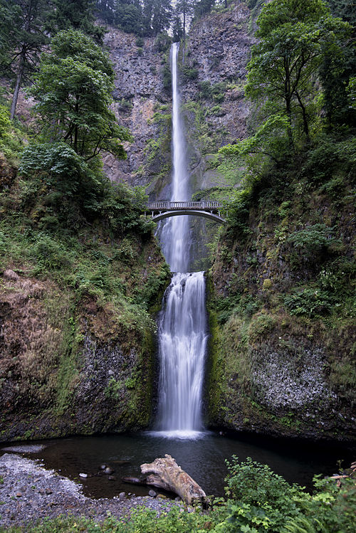
Multnomah Falls

Multnomah Falls

At 620 feet, it is the tallest waterfall in Oregon. Surrounded by hiking trails and bridges.

Vista House

Vista House

Rooster Rock State Park

Rooster Rock State Park

Monolith on the Columbia River. Called iwash (penis) by the Chinook. Has an adjacent nude beach. Picnic and disc golf facilities.

Wahkeena Falls

Wahkeena Falls

242-foot high waterfall.

Plan your trip

Getting there

    Interstate 84, exit 22 for Corbett and 28 for Bridal Veil. Alternately use the Historic Columbia River Highway; most of the destinations are best reached from it.

    Full “Get in” guide ↓

    Budget & where to stay

    No prices are listed for this place yet. See the Sleep guide ↓ for options.

    Sample 2-day itinerary

    Day 1

    • Morning Horse Tail Falls, Multnomah Falls, Benson State Recreation Area
    • Afternoon Wahkeena Falls, Crown Point Country Museum

    Day 2

    • Morning Bridal Veil Falls, Latourell Falls Trailhead/ Guy W. Talbot State Park
    • Afternoon Rooster Rock State Park, Vista House

    Stops are grouped by area so each day needs little backtracking. Check opening hours before you go.

    Food for you

    What to ask about, for your diet

      Diet labels come from each listing's description and cuisine; “likely” means the cuisine usually has good choices, not a promise. Check with the restaurant. Open the food finder

      Photos

      Bridal Veil FallsHorse Tail FallsMultnomah FallsVista HouseRooster Rock State ParkWahkeena FallsLatourell Falls Trailhead/ Guy W. Talbot State ParkBenson State Recreation AreaAinsworth State ParkBridal Veil and Corbett

      Map

      Every listing with a location. Tap a pin for its Google Maps link.

      Get in

      Interstate 84, exit 22 for Corbett and 28 for Bridal Veil. Alternately use the Historic Columbia River Highway; most of the destinations are best reached from it.

      Get around

      The Gray Line operates the Waterfall Trolley between many destinations in this area.

      See

      Bridal Veil Falls

      See Bridal Veil Falls

      ⚠ Last checked Sep 2017 — confirm before you go
      MapsWebsite
      Horse Tail Falls

      See Horse Tail Falls

      176-foot high waterfall near the HCRH. Trail adjacent is steep.

      2.75 miles east of Multnomah Falls on the Historic Columbia River Highway.
      MapsWebsite
      Multnomah Falls

      See Multnomah Falls

      At 620 feet, it is the tallest waterfall in Oregon. Surrounded by hiking trails and bridges.

      📍 50000 Historic Columbia River Hwy, Bridal VeilLargest, free parking lot accessed from I-84, Exit 31 (off-ramp to the left). Gate to off-ramp will close when lot is full. The Historic Hwy access has limited parking for a fee🕒 Daily, 8 AM to 6 PM💲 $5☎ +1 503-6952372Checked Sep 2026
      MapsWebsite
      Vista House

      See Vista House (at Crown Point)

      📍 40700 Historic Columbia River Hwy☎ +1 503 695-2240Checked Sep 2026
      MapsWebsite
      Rooster Rock State Park

      See Rooster Rock State Park

      Monolith on the Columbia River. Called iwash (penis) by the Chinook. Has an adjacent nude beach. Picnic and disc golf facilities.

      I-84 exit 25🕒 6 a.m. to 9 p.m.☎ +1 503-6952261Checked Sep 2026
      MapsWebsite
      Latourell Falls Trailhead/ Guy W. Talbot State Park

      See Latourell Falls Trailhead/ Guy W. Talbot State Park

      Checked Sep 2026
      MapsWebsite

      See Crown Point Country Museum

      📍 36901 E Historic Columbia River Hwy💲 Free, donations welcome☎ +1 503-695-2726Checked Sep 2026
      MapsWebsite

      Do

      Benson State Recreation Area

      Do Benson State Recreation Area

      Disc golf, swimming, and fishing in Benson Lake.

      📍 1-84, Exit 30Eastbound traffic only, 1 mi before Multnomah Falls🕒 6AM-9PM, daily☎ +1 503-695-2261Checked Sep 2026
      MapsWebsite

      Sleep

      Stay Bridal Veil Lodge Bed And Breakfast

      📍 46650 Historic Columbia River Hwy, CorbettOn Historic Columbia River Hwy, or Exit 28 from I-84☎ +1 503-695-6152Checked Sep 2026
      MapsWebsite
      Ainsworth State Park

      Stay Ainsworth State Park

      Seasonal campground with 40 full hookup sites and walk-in tent sites with nearby parking. A hiker-biker camping area does not accept reservations. It is near Interstate 84 and rail line- online reviews disagree how noisy this is in the campground. The park sells firewood, and has a dump station ($10) open to non-campers.

      🕒 Open for camping and day use Mar 21-Oct 31Check-in 4PM · out 1PM☎ +1 503-793-9885 (park info)Checked Sep 2026
      MapsWebsite

      Additional accommodations can be found in Cascade Locks, Troutdale and near the Portland Airport.

      My experience

      Write about your trip here. Notes save automatically in this browser as you type; back them up from My journal.