
Overview
Mount Gilead is a city in West Central Ohio. It is the county seat of Morrow County. The mailing and local reference is Mt. Gilead.
3 sights · 3 things to do · 1 places to eat · 1 bars & cafés · 3 places to stay
Updated from Wikivoyage on 1 October 2026 · Something wrong or missing? Improve it on Wikivoyage
Best things about Mount Gilead
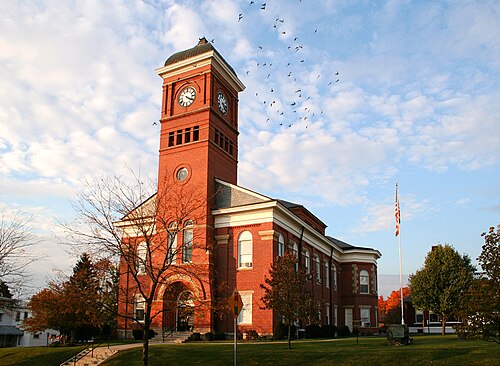
Morrow County Courthouse

James S. Trimble House
Mt. Gilead State Park
4119 State Route 95, for camping. 59 sites with electrical hookups. Boating, trails, camping.
Morrow County Museum
Ohio State Trapshooting Association Facility
Ohio State Trapshooting Association (OSTA), new $1.6 million dollar trap shooting facility.
Morrow County Fair
Plan your trip
Best time to visit & weather
Most comfortable: Apr–Oct. Summer highs reach about 85°F; winter lows dip to about 22°F. Cold months (Jan) can bring snow and ice; check road conditions. Wettest: Jul and Jun. (climate data from nearby Columbus)
Blue bars: average daily high and low (°F). Purple columns: average monthly rain and melted snow (inches).
Getting there
- From you: to see whether to drive or fly, and how long it takes.
- CMH John Glenn Columbus International Airport, Columbus — 38 mi away (major hub). Directions
- LCK Rickenbacker International Airport, Columbus — 51 mi away. Directions
It is located at the intersection of SR 42 and 61 N/S.
Full “Get in” guide ↓Budget & where to stay
No prices are listed for this place yet. See the Sleep guide ↓ for options.
Sample 2-day itinerary
Day 1
- Morning Morrow County Courthouse, Mt. Gilead State Park
- Lunch La Cabiñita
- Afternoon Ohio State Trapshooting Association Facility
- Evening The Endzone
Day 2
- Morning James S. Trimble House, Morrow County Museum
- Afternoon Morrow County Fair
Stops are grouped by area so each day needs little backtracking. Check opening hours before you go.
Food for you
Cuisine (tap to filter)
What to ask about, for your diet
Diet labels come from each listing's description and cuisine; “likely” means the cuisine usually has good choices, not a promise. Check with the restaurant. Open the food finder
Photos


Map
Every listing with a location. Tap a pin for its Google Maps link.
Get in
By plane
- John Glenn Columbus International Airport (CMH), 4600 International Gateway, Columbus. +1 614-239-4083. Direct flights to most major American cities.
By car
It is located at the intersection of SR 42 and 61 N/S.
Get around
There is no public transportation. It is a small town and walking is practical.
See
See Morrow County Courthouse
See James S. Trimble House
See Morrow County Museum
Do
Do Ohio State Trapshooting Association Facility
Ohio State Trapshooting Association (OSTA), new $1.6 million dollar trap shooting facility.
Do Morrow County Fair
Eat
Drink
There is now a small bar and cafe across from the Morrow County Fairgrounds. They have a good selection of beer, including Blue Moon and Sierra Nevada.
Sleep
Hotels
Camping
Go next
Nearby

Galion
City / town · 14 listings · 13 mi away

Lexington
City / town · 23 listings · 16 mi away

Marion
City / town · 31 listings · 16 mi away

Fredericktown
City / town · 10 listings · 16 mi away

Bellville
City / town · 16 listings · 17 mi away

Bucyrus
City / town · 24 listings · 19 mi away

Ontario
City / town · 21 listings · 19 mi away

Mansfield
City / town · 97 listings · 21 mi away
My experience
Write about your trip here. Notes save automatically in this browser as you type; back them up from My journal.