
Overview
Sault Ste Marie (pronounced Soo-Saint-Marie) or (the Soo as called by the locals) is a city of 14,000 people (2010) in the Upper Peninsula of Michigan, across the river from the twin city of Sault Sainte Marie, Ontario in Canada.
7 sights · 1 things to do · 6 places to eat · 2 bars & cafés · 5 places to stay
Updated from Wikivoyage on 1 October 2026 · Something wrong or missing? Improve it on Wikivoyage
Best things about Sault Sainte Marie

Soo Locks
The world’s largest system of locks, including the largest lock in the Western Hemisphere: it has been a major feature of Sault Ste. Marie since the first major lock was built in the mid-19th century.
River of History Museum
It's in the former Federal Building on the waterfront, and has exhibits that will guide you through the fascinating history of the area from the most ancient times to the present. It includes the “Ship’s Store” souvenir …

SS Valley Camp Museum
Housed in a huge retired "laker" - an actual ore-carrying ship. The museum contains many artifacts of maritime history on the Great Lakes, including mementos of the famed Edmund Fitzgerald wreck.
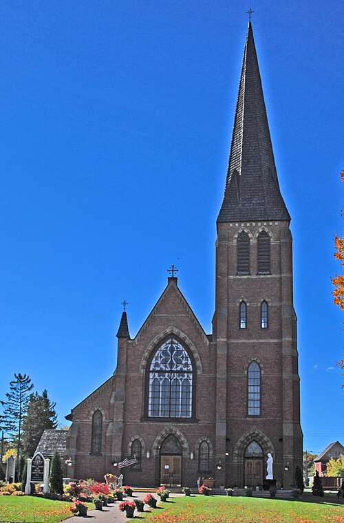
St. Mary’s Cathedral
The oldest church still in use in Sault Ste Marie, built in 1881. Next door to it is the Tower of History was built as a Catholic Church memorial to the early missionaries to the area. This 200-foot-tall tower is a terri…

Lake Superior State University
It's on the former grounds of the second Fort Brady and has a great hockey team. The campus is pretty and well worth a walk through, as it overlooks the wide St Mary's valley and has a view of the International Bridge ov…
Tower of History Museum
A 210-foot (64-m) tower explaining the history of the city and its famous locks, as well as an observation deck to see them and other nearby landmarks and attractions.
Plan your trip
Getting there
- From you: to see whether to drive or fly, and how long it takes.
- CIU Chippewa County International Airport, Kincheloe — 18 mi away. Directions
- PLN Pellston Regional Airport of Emmet County Airport, Pellston — 68 mi away. Directions
- GRR Gerald R. Ford International Airport, Grand Rapids — 256 mi away (major hub). Directions
Sault Ste. Marie is served by Interstate 75 from the south. This is the same highway that links Lower Michigan to the Upper Peninsula via the Mackinac Bridge. Sault Ste. Marie is at the northern terminus of I-75, about 50 miles north of the Mackinac Bridge. Two exits will get you into the Sault. 3 Mile Road is the first (approaching from the south) and takes you through most of the town via Business I-75. This route covers the main thoroughfare in town (Ashmun Street) and eventually gets you to Portage Avenue and the Soo Locks. The second (and last in the USA) exit off of I-75 is Easterday Avenue. This puts you virtually on the campus of Lake Superior State University to the east, or gets you more directly to Portage Ave. and the Locks beyond that. The route is not quite as well-marked, however, and goes through some old and somewhat unattractive industrial areas. You bypass the downtown completely, which may not be so good, as you will miss lots of shopping, hotels and other amenities completely. But if you don't take this exit either, you will end up at the International Bridge toll and customs/immigration plaza for Canada. They will turn you around, without proper identification if you make this mistake. It's a hassle since traffic getting onto the bridge is often backed up in this area. Otherwise, crossing the border is reasonably easy. All you need is proper identification: a passport, passport card, Enhanced Driver's License, NEXUS, FAST, or SENTRI card, U.S. Merchant Mariner Documentation or U.S. Military Identification.
Full “Get in” guide ↓Budget & where to stay
No prices are listed for this place yet. See the Sleep guide ↓ for options.
Sample 2-day itinerary
Day 1
- Morning Edison-Soo Hydro-electric Power House, St. Mary’s Cathedral, Tower of History Museum
- Lunch The Lockview Restaurant
- Afternoon SS Valley Camp Museum, Kewadin Casino, Hotel and Convention Center
- Dinner West Pier Drive-In
- Evening Savoy Bar
Day 2
- Morning Soo Locks, Lake Superior State University
- Lunch Clyde's Drive-In
- Afternoon River of History Museum
- Dinner Antlers Restaurant
- Evening Frank's Place
Stops are grouped by area so each day needs little backtracking. Check opening hours before you go.
Food for you
Cuisine (tap to filter)
What to ask about, for your diet
Diet labels come from each listing's description and cuisine; “likely” means the cuisine usually has good choices, not a promise. Check with the restaurant. Open the food finder
Photos


Map
Every listing with a location. Tap a pin for its Google Maps link.
Understand
The oldest city in the state brings visitors in from around the world to see ships pass through the Soo Locks, where international commerce ships make their way between Lake Superior and the lower Great Lakes. Sault Ste Marie derives its name from nearby rapids and the archaic French word of Sault, which means rapids, or waterfall. The locks and nearby four casinos, as well as the numerous inland lakes, large expanses of forests, wilderness and the Lake Superior shoreline all make for an interesting visit. Across the St. Mary's River and the Canada/US border is its twin city, Sault Ste Marie, Ontario.
History
In 1668, Jesuits established a mission on the south side of the river as Sault Sainte Marie; a fur trading post was later built and settlement expanded to include both sides of the river. Today, the busy Soo Locks carry many large, ocean-going cargo vessels.
For general information about the two cities, see the article for the Canadian side.
Get in
By car
Sault Ste. Marie is served by Interstate 75 from the south. This is the same highway that links Lower Michigan to the Upper Peninsula via the Mackinac Bridge. Sault Ste. Marie is at the northern terminus of I-75, about 50 miles north of the Mackinac Bridge. Two exits will get you into the Sault. 3 Mile Road is the first (approaching from the south) and takes you through most of the town via Business I-75. This route covers the main thoroughfare in town (Ashmun Street) and eventually gets you to Portage Avenue and the Soo Locks. The second (and last in the USA) exit off of I-75 is Easterday Avenue. This puts you virtually on the campus of Lake Superior State University to the east, or gets you more directly to Portage Ave. and the Locks beyond that. The route is not quite as well-marked, however, and goes through some old and somewhat unattractive industrial areas. You bypass the downtown completely, which may not be so good, as you will miss lots of shopping, hotels and other amenities completely. But if you don't take this exit either, you will end up at the International Bridge toll and customs/immigration plaza for Canada. They will turn you around, without proper identification if you make this mistake. It's a hassle since traffic getting onto the bridge is often backed up in this area. Otherwise, crossing the border is reasonably easy. All you need is proper identification: a passport, passport card, Enhanced Driver's License, NEXUS, FAST, or SENTRI card, U.S. Merchant Mariner Documentation or U.S. Military Identification.
By bus
By plane
Go Chippewa County International Airport (CIU)
Formerly the Kincheloe Air Force Base. Delta flies from Chippewa County International to Detroit and Minneaepolis-Saint Paul
Go Sault Ste. Marie Municipal Airport (Sanderson Field SSM)
Also on the Ontario side: Sault Ste. Marie Airport (YAM).
Get around
See
See Edison-Soo Hydro-electric Power House
The world's longest canal-powered electric plant and dominates the shoreline east of the downtown area. Alford Park overlooks the St Mary's River, where you can relax for a picnic lunch to watch the big ships go by. Brady Park, established on the site of the original Ft. Brady, includes a tourist information center, a Japanese torii arch, the famous "musical fountain," and a comfortable atmosphere from which the big ships can be seen going through the locks. In the winter, the world’s biggest snowmobile racing event is held at the I-500 Snowmobile Track.
See Soo Locks
The world’s largest system of locks, including the largest lock in the Western Hemisphere: it has been a major feature of Sault Ste. Marie since the first major lock was built in the mid-19th century.
See SS Valley Camp Museum
Housed in a huge retired "laker" - an actual ore-carrying ship. The museum contains many artifacts of maritime history on the Great Lakes, including mementos of the famed Edmund Fitzgerald wreck.
See St. Mary’s Cathedral
The oldest church still in use in Sault Ste Marie, built in 1881. Next door to it is the Tower of History was built as a Catholic Church memorial to the early missionaries to the area. This 200-foot-tall tower is a terrific place to view the St. Mary’s River and the countryside for many miles around. It also includes museum displays.
See Lake Superior State University
It's on the former grounds of the second Fort Brady and has a great hockey team. The campus is pretty and well worth a walk through, as it overlooks the wide St Mary's valley and has a view of the International Bridge over to Canada. Some beautiful views are at night, as the campus is elevated and you can see the distant lights of the Canadian side.
See Tower of History Museum
A 210-foot (64-m) tower explaining the history of the city and its famous locks, as well as an observation deck to see them and other nearby landmarks and attractions.
Do
Buy
Cascade Crossing Shopping Center houses many stores and shops, and used to have a Walmart, which has since moved down the business spur away from I-75 and closer to town. There are other stores and shops near the downtown waterfront.
Across the International Bridge is the shops of downtown Sault Ste. Marie, Ontario, and the Station Mall with over 100 stores and services. The Station Mall is one of the largest regional shopping centres in Northern Ontario.
Some shops in the "Soo" are centered around sweets and confections, mainly fudge or ice cream. There are also numerous gift shops around the main streets relating to the Soo Locks and large freighters that passed through the locks in their heyday, and some still do.
Eat
Eat The Lockview Restaurant
Amidst the kitschy tourist shops is this restaurant with a large plate-glass front offering views of the passing street traffic. Its Lake Superior whitefish is fresh and excellent! On those hot and muggy days, it is well air conditioned too.
Eat Clyde's Drive-In
This 1950s-style "hamburger stand" has good burgers and fries. It has a large parking area where you eat in your car, and can park facing the beautiful St. Mary's River and watch the lake freighters pass by up close. Closed in winter.
Eat Antlers Restaurant
It's an old-school classic. Steaks and fish. Tons of amazing taxidermy items and arcana hanging everywhere. Numerous steam whistles are mounted to the ceiling and are blown when a local dignitary enters (or whenever they feel the need). The whistles are painfully loud.
Eat The Palace
Offers Americanized Mexican food.
Eat Maloney's Irish Pub
Known for their large number of beers on tap and decent bar food, including a variety of burgers and appetizers.
Eat West Pier Drive-In
Open seasonally, best burger in town, huge portions, a little hard to find.
Drink
Drink Savoy Bar
Open every day but Sunday, with music and dancing.
Drink Frank's Place
Full menu of Italian and American foods, plus a buffet and soup and salad bar. Family owned and operated, huge portion sizes, reasonable prices and many homemade items.
Sleep
Stay Soo Locks Campground
Great place, campground kept clean, on river so you can go fishing, great views of ships coming by. There is a store in the middle of the campground where you can by firewood, food, souvenirs and more. It has an arcade, billiards and a swing set by and in that building. The Ojibway supply boat launches just to the right of the campground.
Nearby

Paradise and Whitefish Bay
Rural area · 9 listings · 36 mi away

Les Cheneaux Islands
City / town · 37 mi away
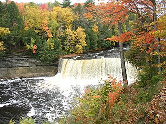
Tahquamenon Falls
Park · 44 mi away

Mackinac Island
Rural area · 7 listings · 47 mi away

Drummond Island
City / town · 13 listings · 47 mi away
St. Ignace
City / town · 3 listings · 47 mi away

Mackinaw City
City / town · 14 listings · 53 mi away

Newberry
City / town · 2 listings · 56 mi away
My experience
Write about your trip here. Notes save automatically in this browser as you type; back them up from My journal.