Overview
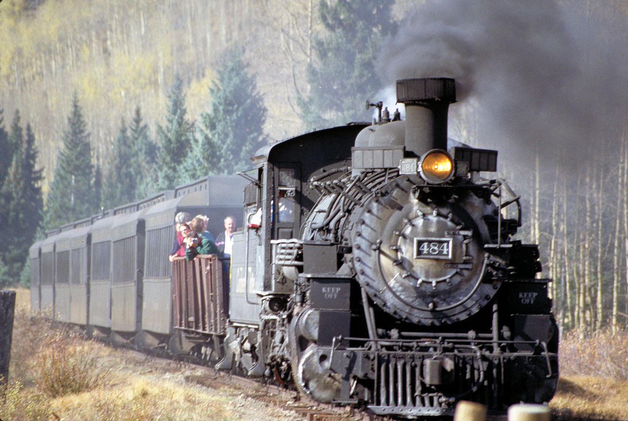
Chama is a small town in north central New Mexico, located in a mountain valley near the Colorado border. The town is noted for its mountain scenery, outdoor recreation, and for being the terminus of a scenic narrow-gauge railroad.
1 sights · 3 things to do · 2 bars & cafés · 7 places to stay
Updated from Wikivoyage on 1 October 2026 · Something wrong or missing? Improve it on Wikivoyage
Best things about Chama
Cumbres and Toltec Scenic Railroad
One of the main attractions of the town. The narrow-gauge railroad runs into the high country near Cumbres Pass, through scenic Toltec Gorge, and on to its opposite terminus at tiny Antonito, Colorado. Tour options range…
Cumbres Pass
Becomes a wonderland for Nordic skiers, snowshoers, and snowmobilers during the winter, owing to the high snowfall that this part of the Colorado Plateau usually receives. Snowpack is variable year to year, but is usuall…
Chama Chili Ski Classic
Held over Martin Luther King, Jr. weekend each year.
El Vado Lake and Heron Lake
Both southwest of town, are scenic reservoirs with opportunities for camping, hiking, fishing, and some boating.
Plan your trip
Best time to visit & weather
Most comfortable: May–Sep. Summer highs reach about 85°F; winter lows dip to about 12°F. Cold months (Jan) can bring snow and ice; check road conditions. Wettest: Aug and Oct. (climate data from nearby Durango)
Blue bars: average daily high and low (°F). Purple columns: average monthly rain and melted snow (inches).
Getting there
- From you: to see whether to drive or fly, and how long it takes.
- ALS San Luis Valley Regional Airport/Bergman Field, Alamosa — 54 mi away. Directions
- TSM Taos Regional Airport, Taos — 59 mi away. Directions
- ABQ Albuquerque International Sunport, Albuquerque — 128 mi away (major hub). Directions
Driving is the primary way to access Chama, and given the town's remoteness, it can be a very long drive. The nearest major airport is in Albuquerque, about a three-hour drive south. Santa Fe is closer (a two hour drive) but has very limited commercial air service. Amtrak's Los Angeles-Chicago Southwest Chief route stops in Albuquerque and the town of Lamy, about 15 miles south of Santa Fe on US Highway 285, with a shuttle that transports passengers between Lamy and Santa Fe.
Full “Get in” guide ↓Budget & where to stay
No prices are listed for this place yet. See the Sleep guide ↓ for options.
Sample 1-day itinerary
Day 1
- Morning Cumbres and Toltec Scenic Railroad, Cumbres Pass
- Afternoon Chama Chili Ski Classic, El Vado Lake and Heron Lake
- Evening The High Country Restaurant and Saloon
Stops are grouped by area so each day needs little backtracking. Check opening hours before you go.
Food for you
Cuisine (tap to filter)
What to ask about, for your diet
Diet labels come from each listing's description and cuisine; “likely” means the cuisine usually has good choices, not a promise. Check with the restaurant. Open the food finder
Photos


Map
Every listing with a location. Tap a pin for its Google Maps link.
Get in
Driving is the primary way to access Chama, and given the town's remoteness, it can be a very long drive. The nearest major airport is in Albuquerque, about a three-hour drive south. Santa Fe is closer (a two hour drive) but has very limited commercial air service. Amtrak's Los Angeles-Chicago Southwest Chief route stops in Albuquerque and the town of Lamy, about 15 miles south of Santa Fe on US Highway 285, with a shuttle that transports passengers between Lamy and Santa Fe.
Chama is located along US Hwy 64 and US Hwy 84, which overlap through the town proper. US 64 continues east over mountainous terrain to Taos (about an hour and a half's drive) and west into Northwest New Mexico. US 84 heads south to Española and Santa Fe, and north into Southwestern Colorado to Pagosa Springs (an hour's drive). No matter which direction you come from, it's a beautiful drive. US 84 from the south is generally open year-round; approaching from Colorado can be problematic in the winter, although it's open more often than not. Limited commuter bus service to Española (with connections to Santa Fe and Taos) is offered by the regional NCRTD service.
Get around
If you've gotten there, you've gotten around; Chama is a small town in which all of the in-town points of interest are within walking distance of each other and the in-town lodging. For reaching the recreational sites near Cumbres Pass, a vehicle with 4-wheel drive and snow tires is desirable during the winter, although the road is plowed frequently. There is a 2500' elevation gain between town and pass that may challenge some automobiles.
See
See Cumbres and Toltec Scenic Railroad
One of the main attractions of the town. The narrow-gauge railroad runs into the high country near Cumbres Pass, through scenic Toltec Gorge, and on to its opposite terminus at tiny Antonito, Colorado. Tour options range from half-way trips to and from a station near the Gorge (delicious, all-you-can-eat lunch is provided) to round trips to Antonito, with return on either rail or bus. Reservations are recommended, as the train fills up during summer weekends. If you're interested in the narrow-gauge train but unable to ride it, the train station has a small set of displays.
Do
There is plenty of outdoor recreation available in the area year-round, including a couple of trail riding stables, fishing, game hunting and fishing, hiking and just overall sight-seeing. Rio Chama and Rio Brazos offer challenging white-water for rafters and kayakers. Snowmobiling, xc-skiing and snowshoeing are popular in the winter.
Do Cumbres Pass
Becomes a wonderland for Nordic skiers, snowshoers, and snowmobilers during the winter, owing to the high snowfall that this part of the Colorado Plateau usually receives. Snowpack is variable year to year, but is usually satisfactory from December through February.
- During the spring/summer/fall there are numerous hiking trails throughout the area. Check out the Sargent Wildlife Area at the north end of Pine Ave., two streets west of Chama's main street which is Terrace Ave. The main trail ends in Chromo, Colorado.
- Chama Days weekend is traditionally the most popular weekend in town. Held on the first weekend in August, Chama Days consists of a weekend of nightlife (several dances a night), sports (2 day rodeo, basketball tournament, softball tournament), and family events (carnival, kids games and pet parade).
Do El Vado Lake and Heron Lake
Both southwest of town, are scenic reservoirs with opportunities for camping, hiking, fishing, and some boating.
Buy
Several souvenir shops are located near the railroad station. There are several shops across from the train station that offer high end and low end articles for sale, original oil paintings with a western theme, eclectic stained glass and southwest jewelry.
Drink
Drink The High Country Restaurant and Saloon
Has a good bar and live music on Friday night.
Drink Foster's Hotel
Also has a bar and pool tables. Both locations sport a lot of "local color."
Sleep
Lodging
There are a number of motels and lodges along the southern approaches to town. Most cater primarily to hunters and fishermen.
Stay Spruce Lodge
Camping
Several of the lodges have associated RV parks, and there are other developed campgrounds in the area, including lakeside camping at El Vado and Heron.
Stay Rio Chama RV Park
Backcountry
The trails around Chama are a haven for the outdoor enthusiast. Many day hikes are accessible at Sargent's Wildlife Park and at the El Vado and Heron Lakes area. The Chama Trail extends between the two lakes for 6-miles. There are unlimited miles of trail for overnight packing trips in the mountains north of Chama, toward Colorado. The historic Continental Divide Trail is undergoing improvements and is open to packers.
Serious adventure in winter camping is available near Cumbres Pass, in the form of a small network of yurts, cabins that can be reached on Nordic (cross-country) skis or snowshoes. The Southwest Nordic Center, based in Taos, maintains the yurts and the reservations for using them; PO Box 3212, Taos NM 87571, +1 575 758-4761. Most of the yurts are 2 to 3 miles (on skis) from the parking lots along the road over the pass; intermediate-level Nordic technique is a good idea for the ski in. Another yurt, the Spruce Hole Yurt, is also available for rental. It is maintained by a local Chama outfit called Cumbres Nordic Adventures.
Go next
- El Chorro Falls, south of Chama, is one of the world's highest waterfalls (ranked around 170th on the list), when it's active. However, it's not active very often, or for very long -- it's produced by spring runoff over the towering Brazos Cliffs, lasts only a few weeks in the spring, and is usually completely gone by June. If you happen to be in the area in April or May, try driving south from Chama on US 64 toward the village of Tierra Amarilla, then east toward the cliffs, and see if you can glimpse it in the distance (no road approaches the falls).
- The Brazos Cliffs themselves are spectacularly scenic and beckon the rock climber, but unfortunately, they're 100% on private property and access is severely restricted. There are some hunting lodges at the base of the cliffs, notably Brazos Lodge and Corkin's Lodge, that include many outdoor recreational opportunities among their (generally pricey) amenities and give good views of the scenery (including El Chorro when it's running); in general, however, they forbid or strongly discourage climbing on the cliffs.
Nearby

Pagosa Springs
City / town · 15 listings · 35 mi away

Abiquiu
City / town · 13 listings · 50 mi away

Rio Grande del Norte National Monument
Park · 6 listings · 52 mi away

Alamosa
City / town · 31 listings · 56 mi away

Cuba
City / town · 8 listings · 64 mi away

Taos
City / town · 49 listings · 65 mi away

Taos Pueblo
City / town · 66 mi away

Red River
City / town · 9 listings · 66 mi away
My experience
Write about your trip here. Notes save automatically in this browser as you type; back them up from My journal.