
Overview
Crawford is a small rural city of about 1,000 people in the Nebraska Panhandle in Dawes County, near the northwest corner of the state. It is three miles east of Fort Robinson State Park.
5 sights · 2 things to do · 3 places to eat · 2 bars & cafés · 3 places to stay
Updated from Wikivoyage on 1 October 2026 · Something wrong or missing? Improve it on Wikivoyage
Best things about Crawford
Co-operative Block Building
Built in 1909 and named after the business it was built for – the Crawford Co-operative Company. This cream-colored two-story building next to Crawford's main street was added to the U.S. National Register of Historic Pl…
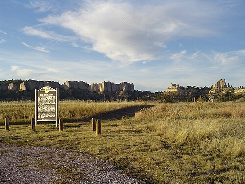
Fort Robinson Museum
A must-see if you're into military history. The Red Cloud Agency, an "Indian agency" (government organization set up to interact with Native Americans), was established here in the 1870s, after which the fort was used by…

Trailside Museum of Natural History
Lots of fossils and bones. If bones and fossils aren't your thing, don't go.
Fort Robinson State Park
Trails, fishing, jeep rides, and an indoor swimming pool.
Crawford Historical Museum
Local hometown museum run by the Crawford Historical Society. Contains a variety of displays and research materials concerning Crawford and the surrounding area.
Post Playhouse
Live theater venue with several showings every week during the summer.
Plan your trip
Best time to visit & weather
Most comfortable: May–Sep. Summer highs reach about 88°F; winter lows dip to about 9°F. Cold months (Jan, Feb, Dec) can bring snow and ice; check road conditions. Wettest: Jun and May. (climate data from nearby Alliance)
Blue bars: average daily high and low (°F). Purple columns: average monthly rain and melted snow (inches).
Getting there
- From you: to see whether to drive or fly, and how long it takes.
- CDR Chadron Municipal Airport, Chadron — 19 mi away. Directions
- AIA Alliance Municipal Airport, Alliance — 53 mi away. Directions
- DEN Denver International Airport, Denver — 206 mi away (major hub). Directions
Crawford is located at the junction of U.S. Highway 20 and Nebraska Highways 2 and 71 and is accessible exclusively by car. The nearest airport is Chadron Municipal Airport, located approximately 25 miles east of Crawford in Chadron.
Full “Get in” guide ↓Budget & where to stay
No prices are listed for this place yet. See the Sleep guide ↓ for options.
Sample 2-day itinerary
Day 1
- Morning Fort Robinson Museum, Post Playhouse
- Lunch Fort Robinson Restaurant
- Afternoon Trailside Museum of Natural History, Fort Robinson State Park
- Dinner Staab's Drive-In
- Evening Frontier Restaurant and Bar
Day 2
- Morning Crawford Historical Museum, Legend Buttes Golf Course
- Lunch Q's Dairy Sweet
- Afternoon Co-operative Block Building
- Evening Diamond Jacks Corner Bar
Stops are grouped by area so each day needs little backtracking. Check opening hours before you go.
Food for you
Cuisine (tap to filter)
What to ask about, for your diet
Diet labels come from each listing's description and cuisine; “likely” means the cuisine usually has good choices, not a promise. Check with the restaurant. Open the food finder
Photos


Map
Every listing with a location. Tap a pin for its Google Maps link.
Understand
When the Fremont, Elkhorn and Missouri Valley Railroad came through the Nebraska panhandle in 1886, a tent city sprang up three miles east of military post Fort Robinson. The town was named after the late cavalry officer Lt. Emmet Crawford, who had been previously stationed at the Fort.
In its early years, Crawford provided entertainment for the soldiers stationed at nearby Fort Robinson, giving the town a reputation for being wild and rowdy. It was an important point for commerce for many years, being located at the junction of two railroads. Crawford's economy also depended largely on Fort Robinson up through World War II, when the Fort contained a German POW camp and a training site for military dogs.
Crawford has since transformed into a quiet rural town. The main local industries are agriculture and uranium mining. The town has become popular as a hunting destination and is visited by tourists traveling to and from the Black Hills National Forest in South Dakota. Fort Robinson, a state park since 1955, has become a travel destination in itself.
The town is far from the oceans and as such the climate is continental with daytime highs in the 80s (around +25–30°C) during the summer. Winter temperatures are usually a bit below freezing. The weather is fairly dry with humidity around 50% around the year, and three rainy days in January and nine in May.
Get in
Crawford is located at the junction of U.S. Highway 20 and Nebraska Highways 2 and 71 and is accessible exclusively by car. The nearest airport is Chadron Municipal Airport, located approximately 25 miles east of Crawford in Chadron.
Get around
The city limits of Crawford are roughly one square mile in size, small enough to walk around in. Travel by car is obviously an option also. The town is connected to Fort Robinson by highway and also by a walking path, beginning at the entrance to Crawford's city park. Crawford's small downtown district can be accessed by turning west on Main Street from Nebraska Highway 2/71 or turning north on 2nd Street from U.S. Highway 20.
See
The adjacent Fort Robinson site is the main attraction of Crawford, albeit there are also a couple of other places of interest.
See Co-operative Block Building
Built in 1909 and named after the business it was built for – the Crawford Co-operative Company. This cream-colored two-story building next to Crawford's main street was added to the U.S. National Register of Historic Places and is still a commercial building.
Fort Robinson
See Fort Robinson Museum
A must-see if you're into military history. The Red Cloud Agency, an "Indian agency" (government organization set up to interact with Native Americans), was established here in the 1870s, after which the fort was used by the army, more specifically the cavalry. You can visit buildings from this period of time, such as a blacksmith shop, veterinary hospital, officers' quarters, guardhouse, adjutant's office and cemetery. Around the time of the world wars, the U.S. Army Remount Service providing horses to the army was stationed here, and during the WWII it also served as a POW camp. After the war the army left, and a museum was opened on the premises in 1955. Eventually the whole fort and surrounding area became a state park and visitor attraction.
Do
Buy
Crawford's small downtown district contains most of the town's shopping options. The businesses include a grocery store, hardware store, pharmacy, quilt shop, second-hand store, several restaurants and bars, and a gift shop or two.
Eat
Eat Q's Dairy Sweet
A vintage drive-up restaurant popular locally because of its barbecued fare.
Eat Staab's Drive-In
A vintage-style drive-up restaurant known locally for its fried chicken and curly fries.
Drink
Drink Diamond Jacks Corner Bar
Somewhat notorious location. Plenty of bikers during the summer.
Drink Frontier Restaurant and Bar (Formerly known as the Frontier Bar and R Bar.)
A well-kept establishment, although bikers are common here also in the summer.
Sleep
There are also multiple bed-and-breakfasts in the rural area surrounding Crawford. Crawford City Park, located at the west end of Main Street, has free camping and electrical hookups; just be aware that the railroad tracks are close to the park and the trains whistle frequently.
Go next
Scottsbluff and Scotts Bluff National Monument are approximately an hour and a half's drive south of Crawford. Chadron, with its museums and state park, is 25 miles east of town. Black Hills National Forest, Mount Rushmore National Memorial, Sturgis, and Deadwood are all north of Crawford in South Dakota.
Nearby

Chadron
City / town · 13 listings · 23 mi away

Alliance
City / town · 18 listings · 49 mi away

Pine Ridge
City / town · 4 listings · 49 mi away

Hot Springs
City / town · 5 listings · 52 mi away

Lusk
City / town · 2 listings · 53 mi away

Scottsbluff
City / town · 12 listings · 58 mi away

Torrington
City / town · 9 listings · 58 mi away

Scotts Bluff National Monument
Park · 6 listings · 60 mi away
My experience
Write about your trip here. Notes save automatically in this browser as you type; back them up from My journal.