Overview
The City of Redding, in Shasta County, California, and its surrounding area has numerous outdoor and indoor activities, including two lakes and two active volcanos within close driving distance. The area offers many parks, hiking trails, and adequate shopping.
Redding is a medium-sized city, and the second largest north of Sacramento after Chico. It is also the county seat and lies along the Sacramento River, an important waterway that provides 35 percent of the state's water. It is the last major city between the start of the Cascade mountain range slightly north and the Oregon border.
4 sights · 12 things to do · 9 places to eat · 8 places to stay
Updated from Wikivoyage on 1 October 2026 · Something wrong or missing? Improve it on Wikivoyage
Best things about Redding

Turtle Bay Exploration Park
Turtle Bay Exploration Park, located along the banks of the Sacramento River, contains a museum and 20-acre (81,000 m²) gardens. The campus features permanent and changing exhibitions highlighting art, history, horticult…
Pilgrim Congregational Church
Designed by Frank Lloyd Wright. A bit tucked away, but worth seeing if you're into architecture.

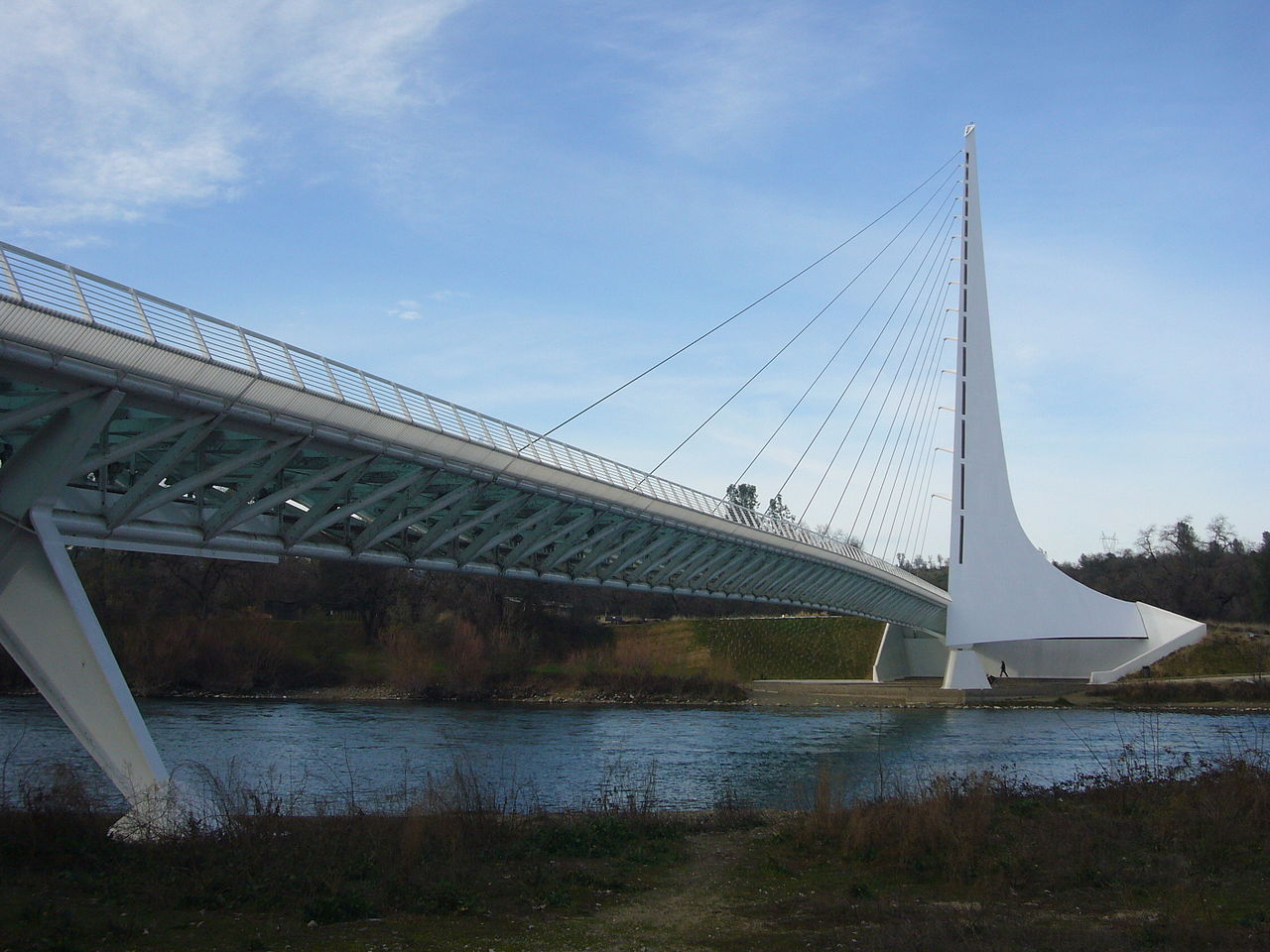
Sundial Bridge
In 2004, the Sundial Bridge at Turtle Bay was completed. The dramatic pedestrian span was designed by the noted Spanish architect-engineer-artist Santiago Calatrava and links the north and south campuses of the 300-acre …
Waterworks Park
A children's aqua park in Redding.
Cascade Theatre
Restored historic theater now hosting concerts, performances, and plays.
Redding Drag Strip
Oldest NHRA drag racing track in the US.
Plan your trip
Best time to visit & weather
Most comfortable: Mar–May, Oct–Nov. Summer highs reach about 100°F; winter lows dip to about 37°F. Very hot (Jun, Jul, Aug, Sep) — plan outdoor time for mornings. Wettest: Dec and Jan.
Blue bars: average daily high and low (°F). Purple columns: average monthly rain and melted snow (inches).
Getting there
- From you: to see whether to drive or fly, and how long it takes.
- RDD Redding Municipal Airport, Redding — 6 mi away. Directions
- ACV California Redwood Coast-Humboldt County Airport, Arcata/Eureka — 95 mi away. Directions
- SMF Sacramento International Airport, Sacramento — 136 mi away (major hub). Directions
RABA Transportation Terminal, is Redding's central bus station for the local city buses (RABA) and other bus lines. The station is at 1530 Yuba St next to the Amtrak Station. It is served by:
Full “Get in” guide ↓Budget & where to stay
No prices are listed for this place yet. See the Sleep guide ↓ for options.
Sample 3-day itinerary
Day 1
- Morning Turtle Bay Exploration Park, Sundial Bridge, Cascade Theatre
- Lunch Damburger
- Afternoon Sculpture Gardens at City Hall, Sacramento River Trail
- Dinner Cinders Wood Fired Pizza
Day 2
- Morning Redding Drag Strip, The Sundial Film Festival
- Lunch Fat Daddy's Gourmet BBQ
- Afternoon Redding Beer And Wine Festival, Banff Mountain Film Festival World Tour
- Dinner Black Bear Diner
Day 3
- Morning Waterworks Park, Shasta Lanes
- Lunch Bartel's Giant Burgers
- Afternoon Lemurian Shasta Classic, Kool April Nites
- Dinner Karline's Restaurant & Bar
Stops are grouped by area so each day needs little backtracking. Check opening hours before you go.
Food for you
Cuisine (tap to filter)
What to ask about, for your diet
Diet labels come from each listing's description and cuisine; “likely” means the cuisine usually has good choices, not a promise. Check with the restaurant. Open the food finder
Photos


Map
Every listing with a location. Tap a pin for its Google Maps link.
Understand
History
Redding was founded as Poverty Flats in 1868 during the gold rush, by a former Sacramento mayor named Benjamin Bernard Redding. He built property in the area so that the Central Pacific Railroad could build a train terminal there. While building the terminal they built the city in the same area, naming it Redding after Benjamin Redding.
Since then the town has gone through various periods of rapid growth, followed by slow downs and then more growth. In the early 20th century Redding had a thriving copper and iron extraction industry. However the town struggled in the twenties with the decline of the mining sector. It came back in the 1930s though and boomed in the 1940s due to the construction of Shasta Dam, which caused the population to nearly double. In the 1950s, the area stayed prosperous thanks to the growing lumber industry and tourism that the dam brought. Interstate 5 was built during the 1960s and 1970s. Further helping the surrounding areas economy.
Redding started to decline again in the early 1980s because of the stricter logging regulations put in place by the federal government that essentially crippled the logging industry. The town continued a slow decline throughout the 1980s, 1990s, and early 2000s.
It has had a slight economic resurgence due to increased business from people visiting the megachurch there.
Visitor information
Get in
By car
- Interstate 5 (I-5) is the main north-south road through Redding, going as far north as Blaine, Washington (near Bellingham) to San Ysidro, California (a community of San Diego). Redding is accessed from Exit 675 to 682 of I-5.
- Highway 44 is the main road to Lassen Volcanic National Park, stretching from Redding in the west to Highway 89 in the east. Many Redding locals go to Lassen National Park using this road in the summer, so that's when it is most crowded. Other times, parts of it are closed due to snow. Goes into downtown as Shasta St (WB) to Pine St and Tehama St (EB) from Market St.
- Market St serves as a 'business loop' of I-5 from Exit 681B, through Redding and Anderson as a local road, and rejoins back to I-5 at Exit 667 south of Anderson.
- Eureka Way is Redding's main link to the coast (namely Arcata) and to northeastern California (Modoc County). It is, however, one of the less-traveled roads because it is very narrow with very sharp curves much of the way.
By train
- Route stopping in Redding:
- Coast Starlight operates daily between Seattle and Los Angeles. Stops include Tacoma, Lacey, Centralia, Kelso, Vancouver, WA, Portland, Salem, Albany, Eugene, Klamath Falls, Dunsmuir, Redding, Chico, Sacramento, Davis, Martinez, San Francisco (Emeryville), Oakland, San Jose, Salinas, Paso Robles, San Luis Obispo, Santa Barbara, Oxnard, Simi Valley, Van Nuys, and Burbank. The southbound train arrives at 2:21AM and the northbound train arrives at 3:06AM, but delays are quite common too.
By bus
RABA Transportation Terminal, is Redding's central bus station for the local city buses (RABA) and other bus lines. The station is at 1530 Yuba St next to the Amtrak Station. It is served by:
Go Amtrak Thruway Motor Coach Rt #3
Connects Redding (via Red Bluff, Chico, Oroville, Marysville, Davis, etc) to the Amtrak Gold Runner and Capitol Corridor trains in Sacramento and only the Gold Runner in Stockton. Tickets on this bus are only available for connections to Amtrak trains. Thruway buses stop at the RABA Transit Center at 1530 Yuba St on the opposite side of the tracks from Redding Station (see below).
Go Greyhound, Flixbus
Greyhound travels primarily on Interstate 5 between Portland and Sacramento via Salem, Corvallis, Eugene, Roseburg, Grants Pass, Medford, Weed, Redding, Chico, Oroville, and/or Marysville. Passengers transfer buses in Portland, Sacramento, Eugene-Springfield, Medford or Los Angeles to reach additional destinations. Some of the buses are direct between Redding and Sacramento. Check schedules.
Go Sage Stage
Connects Alturas to Klamath Falls, Redding, Susanville, and Reno on multiple routes. It may be a shorter way to connect to Klamath Falls and Reno from Redding. Schedules are limited so be sure of the departure and connection times before using this option as they only operate once on Tuesdays to/from Redding.
Place Susanville Indian Rancheria Public Transportation Program (SIR)
Connects Susanville to Chester, Red Bluff and Redding. Passengers connect in Susanville to Lassen (County) Rural Bus to continue to other towns in Lassen County or to another SIR or Sage Stage bus (see above) to continue towards Reno from Susanville. Schedules are limited so be sure of the departure and connection times before using this option especially if going to Reno.
Place Trinity Transit
Connects Redding to Weaverville and Willow Creek (in Trinity County). If you need public transportation to these towns, this is where you go. Willow Creek is also served by Redwood Transit System, which goes all the way to Arcata in Humboldt County from Willow Creek. To go one way from Arcata to Redding (or the other way) it costs $24.35 ($4.35 from Arcata to Willow Creek, $10 from Willow Creek to Weaverville, and another $10 from Weaverville to Redding). You can ask the driver to confirm the fare for each segment. Schedules are limited so be sure of the departure and connection times before using this option. Passengers transfer buses in Arcata to continue to McKinleyville, Eureka, Crescent City or anywhere along the US-Hwy 101 corridor by the coast.
By plane
The next nearest airports for commercial flights with additional airlines are in Medford (MFR) located 152 mi to the north, and in Sacramento (SMF) located 154 mi to the south. Both are directly accessed from the I-5 corridor.
Get around
By bus
RABA (Redding Area Bus Authority) is the city bus line in Redding. It also has routes that go to Burney and Anderson. Their central terminal is at 1530 Yuba Street which is also the place to catch the Amtrak bus and the Greyhound (see "By bus" in the above under "Get In").
By bicycle
Drivers generally cooperate with bicyclists on major roads, but that rule changes dramatically with smaller, less-traveled roads. Other than that, follow the same guidelines on a bicycle as you would in any other city.
By taxi
Place ABC Cab
Place Redding Yellow Cab
See
See Pilgrim Congregational Church
Designed by Frank Lloyd Wright. A bit tucked away, but worth seeing if you're into architecture.
See Sundial Bridge
In 2004, the Sundial Bridge at Turtle Bay was completed. The dramatic pedestrian span was designed by the noted Spanish architect-engineer-artist Santiago Calatrava and links the north and south campuses of the 300-acre (1.2-km²) Turtle Bay Exploration Park. The pylon holds up the bridge support cables and also acts as a sundial (which is accurate only on the summer solstice—June 21 or 22).
Do
Do Sacramento River Trail
A loop trail that starts at the base of the Dieselhorst Bridge, then goes almost to Keswick Dam, crosses a bridge, and goes back. One of the more well-known trails in Redding.
Events
Do The Sundial Film Festival (Yearly)
The Sundial Film Festival is Redding's annual film festival, and awards professional and novice film makers and photographers. Two programs are shown each year; student, animated and assorted films are in the afternoon and the premier films along with photography awards in the evening show
Do Freedom Festival (July 4th)
The Fourth of July Freedom Festival takes place at the Redding Civic Center and includes a family friendly day of picnics, food vendors, live entertainment and a large fireworks display set to patriotic music.
Do Banff Mountain Film Festival World Tour (Yearly)
Banff Mountain Film Festival highlights outdoor adventure and sports and as part of the international world tour and the Redding event showcases local outdoor sports with a Banff Street Fair on the demonstration block in front of the Cascade Theatre and spotlights local vendors and experts in outdoor fun.
Buy
There are many places to shop in Redding, including big-box retail outlets and specialized local stores. The Mt. Shasta Mall and the area around it are great places if you want large department stores, whereas downtown Redding, the Masonic area, and Enterprise all have smaller unique shops, including bookstores, secondhand stores, gift shops and boutiques.
Eat
Eat Jack's Grill
It looks pretty shabby on the outside, but the food and service are nothing short of amazing. Be sure to have plenty of the salad: it's also very good. Scallops are wonderful as well, but the main attraction is the steak.
Eat Karline's Restaurant & Bar
A nice Italian place with good food.
Eat Bartel's Giant Burgers
Home to famous giant burgers sold at this greasy spoon.
Eat View 202
California cuisine served indoors and outdoors. The outdoors seating is popular and offers an incredible view (facing westward) of the Sacramento River and Shasta Bally (a mountain). Sunset time is perfect timing to see the sunset behind the mountain. Outdoor heating is provided in colder months and blankets are made available. Reservations are highly recommended as this is a very popular venue.
Eat Cinders Wood Fired Pizza
Good pizza, try the fiesta ranch.
Sleep
Budget
Stay Motel 6
Mid-range
Splurge
Stay safe
Like many midsize American towns, Redding is fairly safe overall as long as you plan properly and take the same precautions everyone should while traveling in a new place. Although there are no truly unsafe places in Redding, care should still be taken when visiting certain areas of town. For instance, the South Market Street area, including South City Park and The Shasta County Library can be problematic depending. There are also sort of bad areas by Enterprise School. Again though, they are not any more unsafe than comparable lower income neighborhoods in other midsize cities.
Go next
- Shasta - approximately 6 mi west of downtown Redding on Highway 299, Shasta is a Gold Rush-era ghost town, that features an admission free courthouse museum, ruins of several brick buildings, 19th-century cemeteries, short trails, a picnic area, and occasional living history demonstrations.
- Anderson - approximately 10 mi south of Redding on Interstate 5, Anderson is a commercial shopping area with many stores.
Nearby

Shasta
City / town · 2 listings · 6 mi away

Shasta Lake
City / town · 4 listings · 7 mi away

Palo Cedro
City / town · 3 listings · 7 mi away
Anderson
City / town · 11 listings · 10 mi away
Whiskeytown National Recreation Area
Park · 1 listings · 10 mi away
Cottonwood
City / town · 7 listings · 14 mi away

French Gulch
City / town · 2 listings · 16 mi away
Lakehead
City / town · 11 listings · 23 mi away
My experience
Write about your trip here. Notes save automatically in this browser as you type; back them up from My journal.