Overview
Taft is a small community at the eastern foot of the Temblor mountains, in Kern County in the San Joaquin Valley of California. It is not much of a vacation destination although there are sites to see including the oil museum, a historic fort and the Carrizo Plains National Monument. There is also a large tract of BLM lands open to off-road enthusiasts.
2 sights · 3 things to do · 5 places to stay
Updated from Wikivoyage on 1 October 2026 · Something wrong or missing? Improve it on Wikivoyage
Best things about Taft
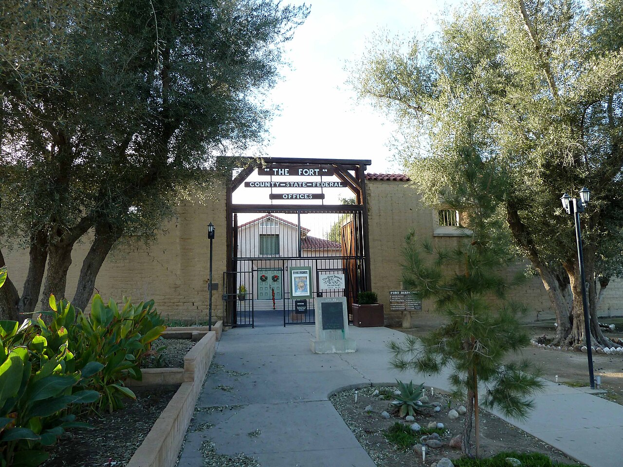
The Fort
The Fort is a replica of Sutter's Fort in Sacramento, built in 1940 of adobe bricks by the government as a depression era project. It is listed on the National Register of Historic Places.
West Kern Oil Museum
This museum tells the story of oil in California.
Air Adventures West
Skydiving either tandem or solo with instruction.
Natatorium Swimming Pool
Swimming pool, splash park, and water slide.
Skydive Taft
Skydiving either tandem or solo with instruction.
Plan your trip
Best time to visit & weather
Most comfortable: Feb–May, Oct–Nov. Summer highs reach about 98°F; winter lows dip to about 41°F. Very hot (Jun, Jul, Aug, Sep) — plan outdoor time for mornings. Wettest: Feb and Jan.
Blue bars: average daily high and low (°F). Purple columns: average monthly rain and melted snow (inches).
Getting there
- From you: to see whether to drive or fly, and how long it takes.
- BFL Meadows Field, Bakersfield — 30 mi away. Directions
- SBA Santa Barbara Municipal Airport, Santa Barbara — 54 mi away. Directions
- BUR Hollywood Burbank/Bob Hope Airport, Burbank — 88 mi away (major hub). Directions
Taft is located at the intersection of CA-33 and CA-119. From the east, Taft is 16 miles from I-5. From the north, CA-33 connects Taft with McKittrick and Coalinga. From the south, CA-33 connects Taft with Maricopa and Santa Maria via CA-166.
Full “Get in” guide ↓Budget & where to stay
No prices are listed for this place yet. See the Sleep guide ↓ for options.
Sample 1-day itinerary
Day 1
- Morning The Fort, Natatorium Swimming Pool, Skydive Taft
- Afternoon West Kern Oil Museum, Air Adventures West
Stops are grouped by area so each day needs little backtracking. Check opening hours before you go.
Food for you
What to ask about, for your diet
Diet labels come from each listing's description and cuisine; “likely” means the cuisine usually has good choices, not a promise. Check with the restaurant. Open the food finder
Photos


Map
Every listing with a location. Tap a pin for its Google Maps link.
Understand
The primary industry of the region is oil and gas production, with some of the most prolific oil fields in the state including the Midway Sunset field being just minutes from the city. Other major employers include a nearby Federal prison and kitty litter mines.
The town has a wide range of services including supermarkets, restaurants, a downtown theater and arts center, a college, and others.
The area is a popular location for film shoots being just a little over 2 hours north of Los Angeles. Movies include the 2007 film There Will be Blood, a period drama about the beginning of the oil industry in the area.
Taft in the past couple of years has marketed itself as the gateway to the Carrizo Plain National Monument and is trying to encourage tourism to the area but there isn't much infrastructure to support tourism as of yet.
There are only about 6 hotels in town which all tend to run a bit on the seedy side but look for improvements in the near future as city planners continue to work to improve the city's visitor services.
Climate
Get in
By car
Taft is located at the intersection of CA-33 and CA-119. From the east, Taft is 16 miles from I-5. From the north, CA-33 connects Taft with McKittrick and Coalinga. From the south, CA-33 connects Taft with Maricopa and Santa Maria via CA-166.
By plane
Get around
See
See The Fort
The Fort is a replica of Sutter's Fort in Sacramento, built in 1940 of adobe bricks by the government as a depression era project. It is listed on the National Register of Historic Places.
Do
Sleep
Stay Sunset Motel
Stay Topper's Motel
Stay Welcome Inn
Go next
- Carrizo Plain National Monument. Take CA-33 south for 16 miles, turn right on Soda Lake Rd. This remote national monument is home to the largest remaining native grassland in California. During wet years it boasts spectacular wildflowers in the spring, and Soda Lake is an important wintering area for waterfowl when precipitation is sufficient to flood the seasonal lakebed. The park is also home to Painted Rock, a Native American site that has been adorned with pictographs over thousands of years. Services are extremely limited, with just a small visitor center, two primitive campgrounds, and a handful of marked trails available.
- McKittrick - An oil & gas town located north of Taft on Highway 33 that is home to the McKittrick Brea Pit, a tar pit that was the site of a huge cache of prehistoric fossils.
- Maricopa - Located south of Taft on Highway 33, this oil & agriculture town was the site of one of the largest oil spills in history when the Lakeview Gusher unleashed nine million barrels of oil onto the surrounding countryside.
- Buttonwillow - Located north of Taft, this town offers additional lodging options and services and is home to the Buttonwillow Tree, a state landmark that gave the town its name.
- Bakersfield - Northeast of Taft. Nicknamed "the country music capital of the West Coast", Bakersfield is the largest city in the southern San Joaquin Valley and is thus the best option for those seeking lodging, transportation, or other services.
Nearby

Maricopa
City / town · 6 listings · 5 mi away

Carrizo Plain National Monument
Park · 6 listings · 16 mi away

McKittrick
City / town · 3 listings · 16 mi away

Buttonwillow
City / town · 7 listings · 20 mi away
Bakersfield
City / town · 39 listings · 28 mi away

The Grapevine
City / town · 9 listings · 32 mi away
Wasco
City / town · 5 listings · 33 mi away

Lost Hills
City / town · 2 listings · 37 mi away
My experience
Write about your trip here. Notes save automatically in this browser as you type; back them up from My journal.