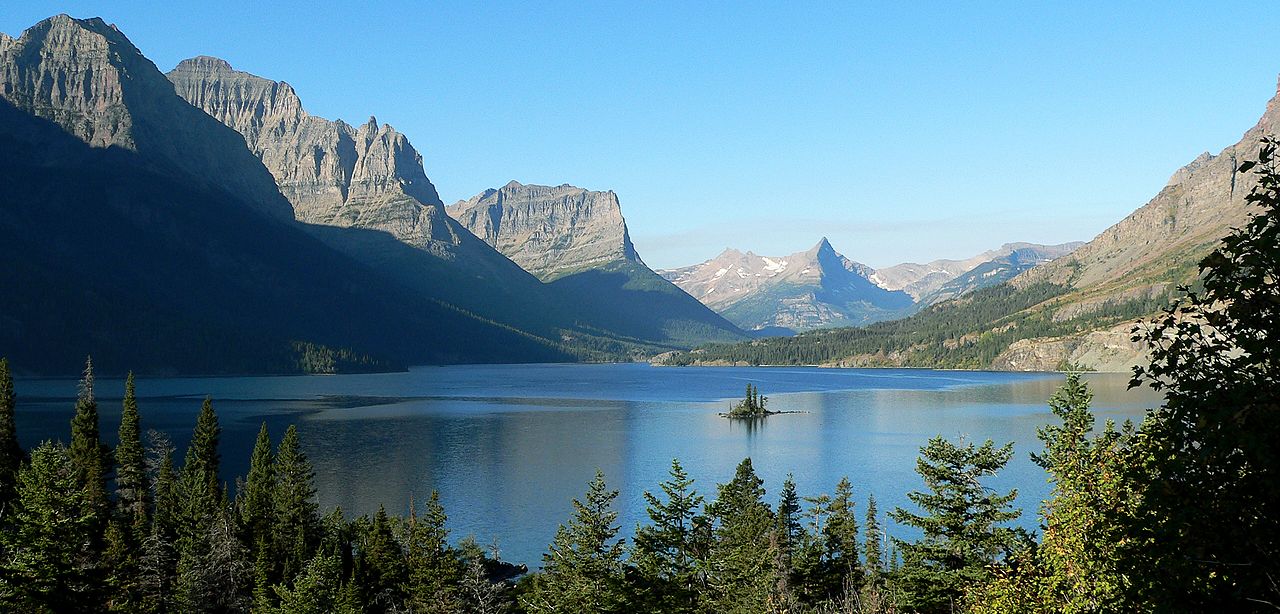
Overview
Northwestern Montana has some of the most varied terrain in the Mountain West. The Bitterroot and Continental Divide branches of the Rocky Mountains flank it on west and east, leaving a mixture of freshwater lakes, prairies, glaciers, rivers, and forests between. It is best known for the sprawling Glacier National Park and the cities of Missoula and Kalispell.
Updated from Wikivoyage on 1 October 2026 · Something wrong or missing? Improve it on Wikivoyage
Plan your trip
Best time to visit & weather
Most comfortable: May–Sep. Summer highs reach about 85°F; winter lows dip to about 18°F. Cold months (Jan, Feb, Nov, Dec) can bring snow and ice; check road conditions. Wettest: Jun and May. (climate data from nearby Missoula)
Blue bars: average daily high and low (°F). Purple columns: average monthly rain and melted snow (inches).
Getting there
- From you: to see whether to drive or fly, and how long it takes.
- MSO Missoula Montana Airport, Missoula — 43 mi away. Directions
- FCA Glacier Park International Airport, Kalispell — 56 mi away. Directions
- GEG Spokane International Airport, Spokane — 168 mi away (major hub). Directions
Missoula International Airport (MSO) and Glacier Park International Airport (FCO) (near Kalispell) have connections throughout the western United States on several airlines. Despite the names, neither has any scheduled service to Canada.
Full “Get in” guide ↓Sample 3-day trip
- Day 1: Missoula — Missoula Art Museum, Missoula County Courthouse, Montana Museum of Art & Culture.
- Day 2: Glacier National Park — Going-to-the-Sun Road, Swiftcurrent Lake, Sperry Glacier.
- Day 3: Troy — Kootenai Falls & Swinging Bridge, Ross Creek Cedar Grove, City Hall.
Built from the best-covered destinations in this region; open each for its own day plan.
Photos


Places in Northwestern Montana

Missoula
City / town · 57 listings

Glacier National Park
Park · 36 listings

Troy
City / town · 31 listings

Whitefish
City / town · 30 listings

Kalispell
City / town · 28 listings

West Glacier
City / town · 22 listings

Libby
City / town · 20 listings

Cut Bank
City / town · 17 listings
East Glacier
City / town · 13 listings
Columbia Falls
City / town · 13 listings

Hamilton
City / town · 13 listings

Browning
City / town · 12 listings

Superior
City / town · 12 listings

Polson
City / town · 11 listings

Lolo
City / town · 9 listings

Babb
City / town · 8 listings
Bigfork
City / town · 6 listings
Eureka
City / town · 5 listings

St. Mary
City / town · 4 listings

Ravalli
City / town · 4 listings

Seeley Lake
City / town · 4 listings

Thompson Falls
City / town · 2 listings
Understand
Northwestern Montana has long relied on its natural resources. Lumber and mining are mainstays of the economy, but those same mountains and forests now draw tourists in great numbers as well.
Winter weather is milder than the rest of Montana, due to the shielding effect of the mountains – the average temperature typically floats between 20 and 40 degrees. Spring is rainy and unpredictable, but summer and autumn are consistently pleasant with late sunsets.
Cities
Bitterroot Valley & area
- Missoula — largest city in the region; home to the University of Montana.
- Lolo — eastern end of the historic Lolo Trail.
- Hamilton — main town in the Bitterroot Valley.
- Ravalli — a village at the intersection of US 93 and MT 200.
- Seeley Lake — known for its cross-country skiing and snowmobiling trails.
- Superior — a small city on the Clark Fork River that is near the beautiful mountain views at Diamond Lake.
- Thompson Falls —a small town along spellbinding Clark Fork River with some cedar trees over 1,000 years old.
Flathead Valley
- Kalispell — base for outdoor activities at West Glacier and the Flathead Valley.
- Bigfork — resort town on Flathead Lake known for renowned artworks and cherry orchards.
- Columbia Falls — known as the Gateway to "Glacier National Park."
- Polson — a small town on the Flathead Indian Reservation.
- Whitefish — one of National Geographic's "Top 25 Ski Towns in the World."
Glacier Country
- Babb — a small settlement on the Blackfeet Indian Reservation just south of the Canadian border.
- Browning — a small town on the Blackfeet Indian Reservation at the intersection US 2 and US 89.
- Cut Bank — county seat for Glacier County.
- East Glacier — a small settlement on the southeastern side of Glacier National Park.
- St. Mary — a small town at the eastern entrance of Glacier National Park.
- West Glacier — a small town at the western entrance of Glacier National Park.
Kootenai Valley
- Eureka — small town near Lake Koocanusa.
- Libby — near the Kootenai National Forest and Kootenai River; popular with hunters.
- Troy
Other destinations
- Glacier National Park has innumerable opportunities for hiking, fishing, boating, and camping, on a vast scale – the park is bigger than the entire state of Rhode Island.
Get in
By plane
Missoula International Airport (MSO) and Glacier Park International Airport (FCO) (near Kalispell) have connections throughout the western United States on several airlines. Despite the names, neither has any scheduled service to Canada.
By car
Interstate 90 passes through Missoula, connecting from Idaho on the west towards Southwestern Montana and Butte on the east. U.S. Route 12 overlaps I-90 through most of western Montana, until diverging at Garrison and continuing east to Helena.
Further north, the scenic U.S. Route 2 connects Kalispell and the west entrance to Glacier Park, then skirts the southern boundary of the park as far as East Glacier before entering the plains of Central Montana.
The major north-south artery is U.S. Route 93, linking almost every city in the region and continuing to Twin Falls, Idaho. Route 93 is prone to clogging with traffic, particularly on summer weekends.
By train
Amtrak operates the Empire Builder service daily between Seattle/Portland and Chicago. Stops are made at Libby, Whitefish, West Glacier, Essex (flag stop), East Glacier (seasonal – summer), Browning (seasonal – winter), and Cut Bank.
By foot
For the dedicated long-distance hiker, the Continental Divide Trail is a National Scenic Trail running 3,100 miles between Mexico and Canada. It follows the Continental Divide of the Americas along the Rocky Mountains through Montana, Idaho, Wyoming, Colorado, and New Mexico.
Get around
A car is essential for most travel through the region.
See
- Within Glacier National Park, the Going-To-The-Sun Road crosses the park from west to east, offering spectacular panoramas. At the midpoint, the Logan Pass Visitor Center is the base for a variety of short, scenic hiking trails.
- The Flathead Valley contains still more outdoor activities, including Flathead Lake and two ski resorts.
- Seeley Lake, southeast of Glacier Park, is a less-crowded alternative with more convenient access to Missoula.
- The St. Ignatius Mission, in St. Ignatius near Ravalli, has historical roots extending to the 1830s, and some of the most beautiful church murals in Montana. The log cabin outside the main church has nuns' headstones worked into the floor and walls--an unusual feature in this area.
- The Garden of One Thousand Buddhas is a stunning Tibetan Buddhist site in Arlee, near Ravalli. One thousand Buddha statues radiate in wheel spokes from a twenty-four-foot Prajnaparamita hub, in the midst of the Jocko Valley, which is, itself, no scenic slouch.
Do
Outdoor activities galore — camping, hiking, fishing, hunting, boating, golfing, rafting, etc. Between Glacier, numerous state parks, and the private resort areas, it's almost harder to find some place where these aren't options.
The area has several major ski resorts. Whitefish Mountain and Blacktail Mountain are the largest in the Flathead Valley/Kalispell area, and the Montana Snowbowl is near Missoula. Lookout Pass straddles the Idaho — Montana state line, allowing the unusual opportunity to ski through two states on one run.
Stay safe
Roads
Winter driving is challenging here. Smaller secondary roads are often closed entirely, and even the interstates can shut down rapidly when the weather turns poor. Verify weather conditions and road status with the Montana Department of Transportation before setting out, and travel with emergency supplies. Unpaved roads are typically impassable for over half the year.
Wildlife
Though many of the animals in the area are used to seeing humans, the wildlife is nonetheless wild and should not be fed or disturbed.
- Stay at least 100 m away from bears and 25 m from all other wild animals! No matter how docile they may look, bison, elk, moose, bears, and nearly all large animals can attack, and every year dozens of visitors are injured because they didn't keep a proper distance. These animals are large, wild, and potentially dangerous, so give them their space. Be especially cautious while traveling at night as animals (especially deer) are known to wander onto roadways.
- Never feed wild animals, especially predators. There are many reasons for this, but amongst them is that animals who become habituated to being fed by humans may be considered a nuisance. Bears and predators that frequent places that humans go, and cannot be broken of the habit, are subject to being killed as a safety precaution. Indirectly, whoever feeds the animals would be responsible for their deaths.
- Store and dispose of food properly in wild areas. If you are not already familiar with proper procedures, read through guidelines before you go.
Weather
The weather can change rapidly and with little warning. A sunny, warm summer day can quickly become a cold, rainy or even snowy experience. Hypothermia can be a concern. Be prepared for a variety of weather conditions by bringing along appropriate clothing. Lightning can and does injure and kill people in the area, so watch the sky and take shelter in a building if you hear thunder.
Hiking and camping
There's no reason to fear the mountains, as long as you approach them with proper respect and preparation. As with anywhere else, recklessness and a lack of forethought can get you into trouble.
- Altitude sickness - Can lead to dizziness, headaches, nausea, even blackouts and pulmonary edema. Give your body a few days to adjust to the high altitudes before going full throttle with your hiking or skiing.
- Dehydration - When you engage in strenuous outdoor activities, be sure to replenish your fluids as you go. You may be losing moisture through your mouth and nose and through sweating, but be completely unaware due to the arid mountain air. May result in dizziness, intense thirst and elevated heart and breath rates.
- Hypothermia - Prolonged exposure to the cold can result in confusion, a slowed heart rate, lethargy, even death. Dress warmly in non cotton clothing to allow any sweat to wick away from your body and evaporate. Otherwise, it may thoroughly chill you later in the day when temperatures drop.
- Frostbite - During periods of severe cold, your circulatory system pulls all your warming blood into the core of your body to protect your vital organs. This makes your extremities such as your ears, fingers and nose especially vulnerable. Wear a face mask, insulated gloves and other heavy gear on the worst winter days. It gets cold sitting still on those ski lifts!
- Sunburn - Lather up with sunscreen, even if there's cloud cover. Montana's high elevation means you have less protection to the sun's powerful ultra violet rays. This can be compounded while skiing or snowboarding, when the rays are reflected off the snow and hits the underside of your jaw. Don't forget to wear UV-rated goggles or sunglasses, as well.
- Know your 10 essentials when going on a hike, because cell phones won't always work in many rural areas, and may not be depended on in an emergency situation.
- Do not drink untreated water from regional streams, owing to Giardia parasites. (Tap water is not a problem.)
Go next
- Central Montana
- Southwest Montana
- Northern Idaho
- North Central Idaho
- Kootenays, British Columbia
- Southern Alberta. Glacier Park is joined across the Canadian border with Waterton Lakes National Park.
My experience
Write about your trip here. Notes save automatically in this browser as you type; back them up from My journal.